Large-Scale Landslide Disaster Reduction
- Update:
- Views: 2727
Prevention and monitoring of large-scale collapse
⑴ Strengthen the crisis response capacity of large-scale collapse
ARDSWC used the potential large-scale landslide areas to conduct multi-scale monitoring, and analyzed the large-scale landslide potential area and its occurrence mechanism by means of large-scale wide-area radar image (TCP-INSAR), mesoscale surface displacement observation system monitoring (single-frequency GPS) and small-scale detailed monitoring. In addition, 186 objects in the initial impact area and inventory area of large-scale collapse were continuously planned, and the management value of large-scale collapse warning value was developed based on the monitoring data, which can be used as a reference for evacuation in the future. In order to integrate the international research on large-scale collapse and disaster prevention technology, scholars at home and abroad were invited to hold the "Seminar on Large-scale Collapse Prevention and Mitigation Technology" and the 2nd expert consultation meeting of the "Large-scale Collapse Prevention and Mitigation Plan under Climate Change" on November 4, 2019. On May 27, 2019, it held a joint drill on the barrier lake of soil and water conversation forest with Water Resources Agency, Forestry Bureau and the affiliated units of Kaohsiung City under ARDSWC and the Government of Kaohsiung City, as well as invited Japanese experts and scholars, to establish a crisis and risk management mechanism and reduce the loss of personnel and property.
-
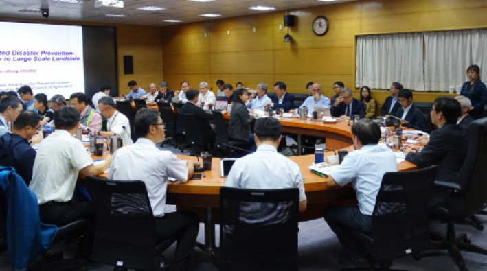
Expert consultation meeting on Large-scale Collapse Prevention and Mitigation Plan under Climate Change (2019/11/7) -
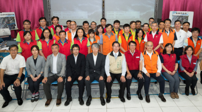
Joint drill on barrier lake of soil and water conversation forest (2019/5/27)

⑵ Establish the smart disaster prevention system for large-scale collapse soil-sand disaster areas
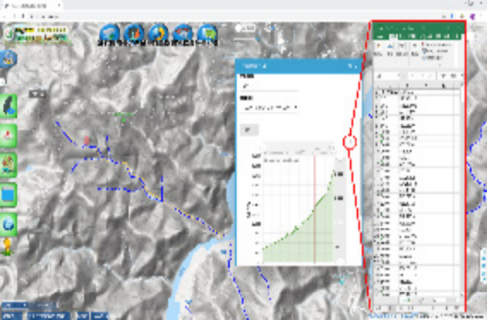
Multi-scale monitoring was conducted for the potential large-scale landslide areas, and the timed receiving method was integrated into the large-scale landslide monitoring database and query system. In 2019, the automatic monitoring results of 34 priority areas of the potential large-scale landslide areas were included, and the user interface of the system was improved. Through the monitoring dashboard module, the monitoring data can be visualized to identify whether the monitoring results are close to or exceed the yellow or red alert value, so as to improve the ability of early warning and response to disasters, fully implement risk management, and improve the smart disaster prevention system.
-
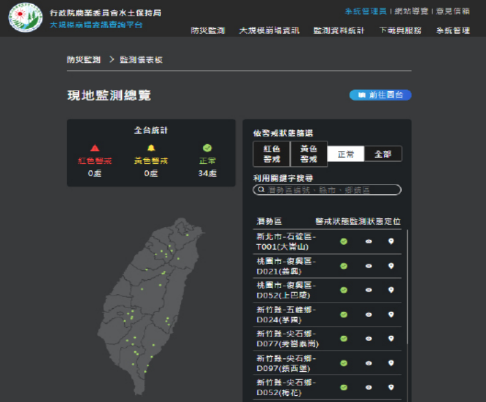
The integrated query system dashboard module for large-scale landslides -
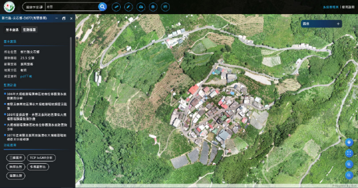
The integrated query system dashboard module for large-scale landslides (Map) -
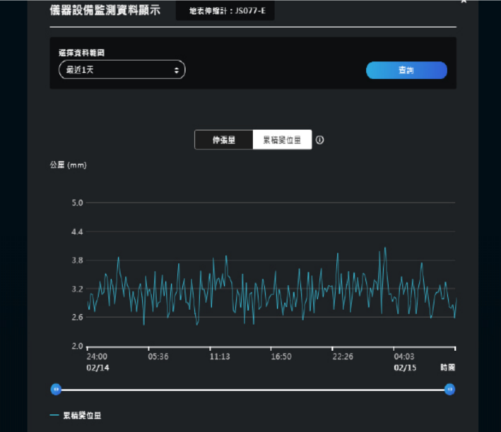
The statistical chart of monitoring data of the integrated query system for large-scale landslides
⑶ Improve the management effectiveness of large-scale sediment disaster areas
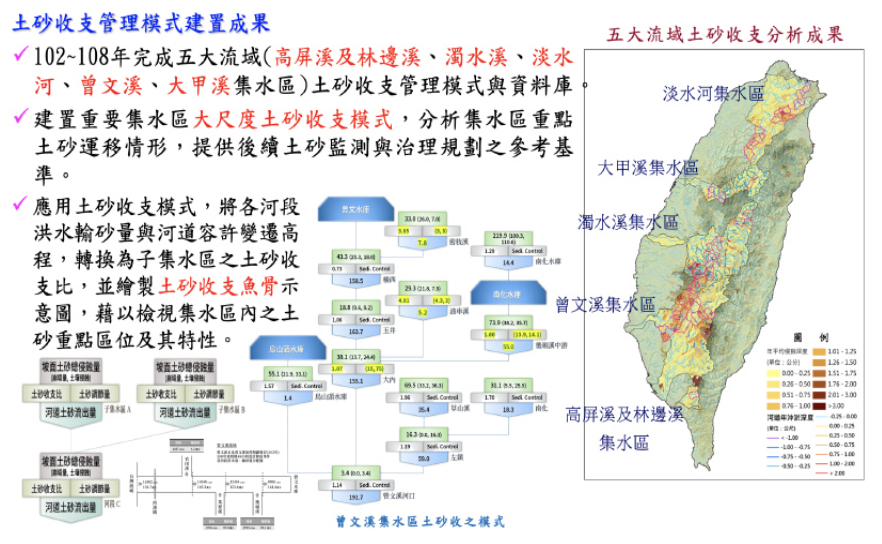
ARDSWC mainly conducted surveys in large-scale collapse areas to assess possible impacts and impacts and established the environmental sediment monitoring system to simulate and analyze the variations. Based on the protection capabilities of sediment control facilities, ARDSWC formulated engineering and non-engineering adaptation countermeasures to improve management efficiency and reduce the volume of sediment in the watershed area.
⑷ Enhancement of conservation of resources in large-scale sediment disaster areas
Climate change regulation of soil and water resources in the large-scale sediment disaster areas was done and included slope vegetation, soil erosion, flood detention space, and farming ponds to achieve the effect of soil and water conservation, thus establishing the model for reasonable utilization of soil and water resources and sustainable operation and management of resources. In 2019, soil and water resource investigation and evaluation of 6 large-scale sediment disaster areas were completed, 5 soil and water resource application evaluation and efficacy studies for large-scale sediment disaster areas were completed and 3 technical improvements of water and soil resources in large-scale sediment disaster areas were completed.
-
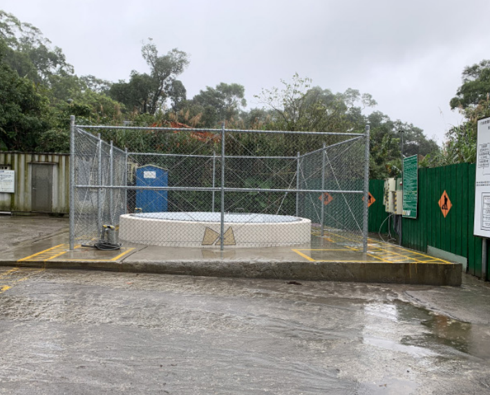
Renovation Project of Dalun Mountain in Shiding District (Shiding District, New Taipei City) -
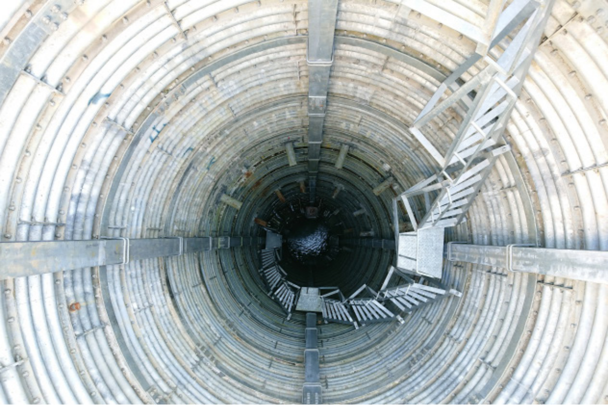
Phase I water-collecting well project of Songmao landslide integral treatment (Heping District, Taichung City)
⑸ Promotion of soil and water conservation and management of large-scale sediment disaster areas
In view of the fact that the range of slopelands has changed with the local environment and surface features over the years. In order to make the slopeland area conform to the laws and regulations and the current conditions, a comprehensive inspection of the slopeland area of counties and cities outside the municipality directly under the central government of Taiwan was carried out. and The areas where the boundary line of slopelands has deviated were rechecked and digitized, so as to complete the change plan of slopeland area of each county and city, and update the land use information of the slopeland in Nantou County, Chiayi County, Chiayi City, Tainan City, and Kaohsiung City, and provide a reference for the management of soil and water conservation of slopelands.
To facilitate the estimation of soil loss, the design of grit basins for soil and water conservation projects and the erosion control of watershed areas, the rainfall and erosion index were re-investigated year by year in Taipei, Taichung, Tainan and Taitung. The work results and distribution information over the years were summarized. The analysis and query system was established, to quickly query the relevant indices and the erosion of soil in Taiwan. At the same time, the filing management, and maintenance management of permanent soil and water conservation facilities that have been completed and planned to be completed were reviewed and analyzed, so as to facilitate the follow-up maintenance and management.
-
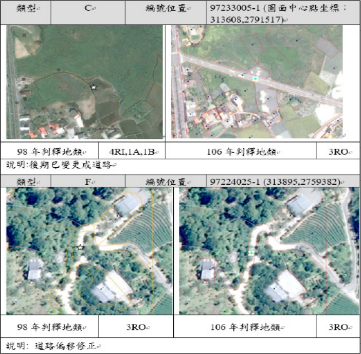
Updating records of land use types -
Value-added application HOST and aspect map, slope map integration overlay review -
Land vulnerability index and watershed area stability index -
Overlapping cadastral map of control project area
⑹ Summarization of information on disaster prevention and reduction of large-scale sediment disaster areas
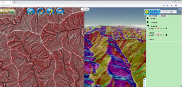
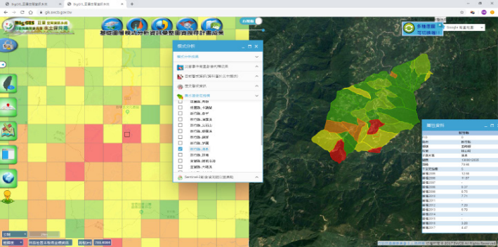
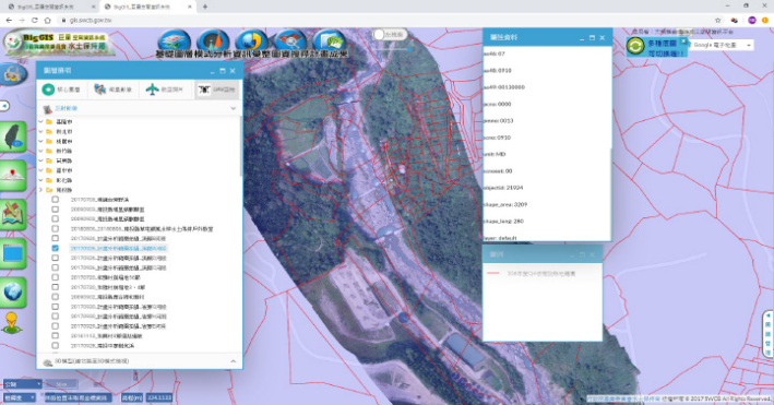
The Big Geospatial Information System (BigGIS) fully supports open source. Aiming at the characteristics of ARDSWC's construction and application of massive space information, the "Big Geospatial Information System (BigGIS)" integrates data into the space database in accordance with international standards with the effective, expanded and consistent file standardization processing technology. Users can set any time, space or other properties to quickly search a huge amount of information and display it on an Internet information platform with 2D/3D, regional 3D, single/double Windows and Google Street View interface. The format and quality of the information were controlled from the source through various information upload interfaces, and APIS were provided to achieve the goal of convenient sharing. The self-defined graph style was further developed, which integrates the external vector information with various model analysis results. Users can carry out the online operation and download the analysis results on the platform to achieve the effective integration and application of resources. In total, it has processed 56TB of space information, including aerial photos, satellite images, aerial photos of unmanned aerial vehicles, numerical elevation models, relevant basic information and various core information required by the business. It is a new generation space information system that meets the characteristics of ARDSWC's construction and application of a huge amount of space information.
-
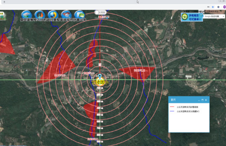
Annular domain analysis on potential debris flow torrent distribution–Nantou Count y Guohsing Township Beigang Elementary School -
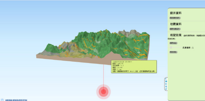
Regional 3D module information window - seismic data properties -
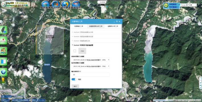
The Sentinel-2 time series image of Wanda reservoir from BigGIS -
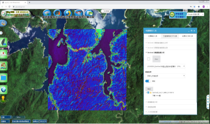
The burning index of Sentinel-2 satellite image calculated by BigGIS -
Application of Digital Elevation - vertical and horizontal section of the area of interest, and download of numerical data